I was traveling from Austin, TX to Fort Lauderdale, FL when I noticed this navigational fix along my route. This was the first time I've done this flight and the first time I've seen this. Thought you guys might get a kick out of it.
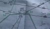
This is from a high-altitude navigation chart for the Southeast U.S. and it depicts an airway in the Gulf of Mexico from Texas'ish to to Southeast Florida. All fixes are 5 characters and this one fits it perfectly. Someone in the FAA who names these points must enjoy our hobby as well.
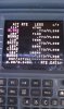
Here's the route as it shows on our FMC, or Flight Management Computer.
Here's the airway on our moving map flying into Fort Lauderdale.
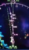
And yes, there were some impressive-looking thunderstorms in the gulf that day that we had to avoid.
You guys in Kansas City have one of the better approach charts, however:
http://155.178.201.160/d-tpp/1206/00780IL1R.PDF
The waypoints for the Runway 1R approach chart read:
'SPICY' BARBQ' 'TERKY' 'SMOKE' 'RIBBS'
Always get a kick out of that.
This is from a high-altitude navigation chart for the Southeast U.S. and it depicts an airway in the Gulf of Mexico from Texas'ish to to Southeast Florida. All fixes are 5 characters and this one fits it perfectly. Someone in the FAA who names these points must enjoy our hobby as well.
Here's the route as it shows on our FMC, or Flight Management Computer.
Here's the airway on our moving map flying into Fort Lauderdale.
And yes, there were some impressive-looking thunderstorms in the gulf that day that we had to avoid.
You guys in Kansas City have one of the better approach charts, however:
http://155.178.201.160/d-tpp/1206/00780IL1R.PDF
The waypoints for the Runway 1R approach chart read:
'SPICY' BARBQ' 'TERKY' 'SMOKE' 'RIBBS'
Always get a kick out of that.
")